Mount Roraima:
The Ultimate Guide to the Lost World Mountain

You stand before one of South America’s most striking mountains, where sheer cliffs rise from the forest and a wide stone top stretches into the clouds. Mount Roraima feels remote and calm, yet it draws steady attention from hikers, scientists, and locals.
Mount Roraima is a flat-topped mountain on the border of Venezuela, Brazil, and Guyana, known for its ancient rock, high cliffs, and rare plants and animals. Its summit sits more than 2,800 meters above sea level and holds pools, caves, and open stone shaped by heavy rain over millions of years.
As you explore its story, you uncover why this mountain matters. Its isolation protects unique life, its past links to early explorers and Indigenous culture, and its trails offer one of the most unusual hikes on the continent.
Key Takeaways
Mount Roraima rises at the meeting point of three South American countries.
The mountain holds ancient rock and rare plants found nowhere else.
Guided hikes allow access while limiting damage to the landscape.
East Venezuela
More Destination
REQUEST

Location and Geography
Mount Roraima rises where national borders, ancient rock, and high plateaus meet. You find a flat summit, steep cliffs, and remote terrain shaped by long erosion and heavy rain.
Triple Border Zone
You stand at a rare triple border where Venezuela, Guyana, and Brazil meet. Mount Roraima, also called Monte Roraima or Roraima Tepui, sits at this shared point.
The mountain forms part of the Pakaraima Mountains, with most of its area inside Venezuela. Smaller sections extend into Guyana and Brazil. The highest point in Guyana lies on the northern edge of the plateau, while the overall highest summit sits on the Venezuelan side.
Steep cliffs rise 400 to 1,000 meters on all sides. Water flows off the plateau and drops as waterfalls, including Triple Point Falls, near the border marker.
Canaima National Park and Gran Sabana
You reach Mount Roraima from Venezuela’s Gran Sabana, a wide region of grasslands and tepuis. The mountain lies within Canaima National Park, a protected area known for large waterfalls and open plains.
The park protects both the base and access routes to Roraima. Trails cross savanna, rivers, and forest before reaching the cliffs. Most hikers enter from the Venezuelan side because roads reach closer to the mountain.
The Gran Sabana sits at a high elevation, which shapes the cooler climate. Clouds, mist, and frequent rain affect travel and visibility throughout the year.
Guiana Shield and Surrounding Regions
Mount Roraima rises from the Guiana Shield, one of the oldest rock formations on Earth. You see thick sandstone layers formed over 1.7 billion years ago.
The mountain is a classic tepui, also called a tabletop mountain. These flat-topped plateaus dominate the Guayana Highlands and stand apart from the surrounding lowlands.
Roraima’s isolation shapes the land around it. Rivers begin near its base and flow toward the Amazon and Orinoco systems. Sharp elevation changes create clear borders between forest, cliff, and summit terrain.
Our Sabana Travel Packages


Geology and Formation
Mount Roraima shows how very old rock, slow uplift, and long erosion shaped a rare tabletop mountain. You can see ancient geological formations, strong sandstone layers, and sharp cliffs that define this tepui.
Ancient Geological Origins
You stand on one of Earth’s oldest geological formations when you reach Cerro Roraima. The rocks formed between 1.7 and 2 billion years ago as part of the Guiana Shield. These rocks predate most plant and animal life on land.
Tectonic uplift raised the land over time. Erosion then stripped away softer layers around it. This process left isolated plateaus, known as tepuis, rising above the savanna.
Mount Roraima sits at the border of Venezuela, Brazil, and Guyana. Its age reflects the deep history of the South American Plate and the long stability of this region.
Sandstone and Quartzite Features
Most of Tepuy Roraima consists of sandstone, with sections hardened into quartzite. Sandstone formed from compacted sand in ancient river and desert systems. Heat and pressure later turned some layers into quartzite.
Quartzite resists erosion better than softer rock. This strength helps explain the mountain’s steep sides and flat top. You can often see clear layers in the rock walls.
Common rock features include:
Sharp ledges and blocks
Smooth rock basins carved by water
Cracks and joints widened over time
These features give the mountain its rugged surface.
Tepui Formation and Rock Structures
Tepuis form when uplifted plateaus erode unevenly. Hard rock stays in place while softer rock disappears. This process creates the classic tabletop mountain shape.
Mount Roraima rises about 2,810 meters above sea level. Its vertical cliffs reach nearly 1,000 meters in some areas. Waterfalls drop straight from the edges during heavy rain.
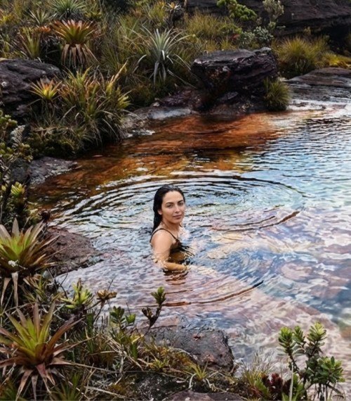
On the summit, you walk across strange rock formations. These include rounded stones, shallow pools, and honeycomb patterns. Wind, rain, and chemical weathering continue to shape these surfaces today.
Largest Quartz Cave
Near Mount Roraima lies one of the largest quartz caves in the world, known as Cueva de Quarzo. The cave formed entirely in quartzite, which is rare.
Water slowly moved through fractures in the rock. Over time, it widened these paths into long tunnels and chambers. The cave stretches several kilometers underground.
Inside, you find smooth white walls and sharp angles. These features show how strong quartzite can still break under constant pressure. The cave adds to the mountain’s unique geological features and scientific value.

Unique Ecosystems and Biodiversity
You find one of the most isolated ecosystems on Earth on Mount Roraima. Long separation from nearby lowlands shaped high levels of biodiversity and many species that live nowhere else.
Endemic Flora and Fauna
You see endemic flora and fauna that evolved in isolation on the summit. Steep cliffs limit movement, which keeps plants and animals separate from surrounding regions. This isolation supports many endemic species found only on this tepui.
Plants grow slowly in thin, acidic soils. Many adapt to constant mist and heavy rain. Animals also show narrow ranges and special traits.
Examples of endemic life include:
Roraima toad (Oreophrynella quelchii)
Roraima climbing mouse, also called the Roraima mouse
Several plant species found only on Mount Roraima
Carnivorous Plants and Orchids
You notice many carnivorous plants that survive in nutrient-poor soil. These plants trap insects to gain nitrogen and minerals that the ground lacks.
Common species include:
Heliamphora nutans (sun pitcher plant)
Utricularia quelchii (a bladderwort)
Sundew, including Drosera felix
You also find small but hardy orchids and bromeliads. Many grow close to rock surfaces and collect water from mist and rain. Their compact size helps them resist strong winds and temperature changes.
Distinctive Wildlife
You encounter wildlife that shows clear signs of long isolation. The Roraima toad lacks a tadpole stage. It develops fully inside eggs, which protects it from cold water and fast runoff.
Small mammals like the Roraima climbing mouse adapt to rocky terrain and limited food. Bird life remains limited but specialized. The greater flowerpiercer visits the slopes and edges, where flowering plants grow in denser patches.
Most animals rely on narrow food sources. This dependence makes each species closely tied to its habitat.
Biodiversity Conservation
You depend on conservation to protect Mount Roraima’s unique ecosystems. Many species exist in small populations and face high risk from disturbance.
Key threats include:
Uncontrolled tourism
Habitat damage from foot traffic
Climate change affecting rainfall and temperature
Protected status within Canaima National Park helps limit damage. Guided access and strict rules reduce pressure on fragile areas. Respect for indigenous Pemon traditions also supports long-term biodiversity protection.

Cultural and Historical Significance
Mount Roraima shapes identity, belief, and history in the Guiana Highlands. You see this through Indigenous traditions, long-held myths, and its role in exploration and literature.
Indigenous Pemon and Kapon Beliefs
You encounter Mount Roraima as sacred land for the Indigenous Pemon and Kapon peoples. The Pemon people call it Roroi, a place tied to daily life and spiritual duty. They treat the summit and cliffs with care and limit access through custom.
Many Pemon describe Roraima as a house of spirits. You hear rules tied to weather, hunting, and travel that reflect respect for these spirits.
Key beliefs you should know include:
Sacred origin tied to creation stories
Spiritual presence that demands respectful behavior
Cultural guidance passed through oral teaching
These beliefs still guide how local guides lead visitors today.
Legends and Mythology
You learn that Pemon stories explain Roraima as the stump of a giant tree that once held all food plants. When the tree fell, floods spread across the land. This story explains rivers, seasons, and survival.
Other myths describe spirit beings living on the plateau. Mist, sudden storms, and strange rock shapes reinforce these ideas. You understand why elders warn against careless actions on the mountain.
The name Roroi appears often in these stories. It links place, memory, and duty. For you, these legends offer a clear view of how landscape and belief connect in a practical way, not as fantasy.
Influence on Literature and Exploration
You see Roraima’s impact on global culture through exploration and books. In 1884, Everard im Thurn led one of the first recorded ascents. His reports shaped how outsiders understood the mountain.
These accounts later influenced Arthur Conan Doyle. You can trace Roraima’s flat summit and isolation in The Lost World. The setting reflects real features, not fiction alone.
This link between place and story changed how readers viewed remote landscapes. You still see Roraima described as ancient, isolated, and distinct, based on early records and lived Indigenous knowledge.

Climbing and Trekking Mount Roraima
You reach Mount Roraima through remote land, follow a set trekking route, and rely on local support to complete the climb. The hike combines long walking days, changing weather, and time on the flat summit plateau with its distinct landmarks.
Access and Main Routes
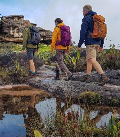
You can only climb Mount Roraima from the Venezuelan side. The journey starts in Santa Elena de Uairén, the main supply town for trekkers. From there, you travel by road to the Pemón village of Paraitepui, where the trek begins.
Almost all climbers use the Paraitepui route, the only non-technical way to reach the summit. You walk across open savanna, cross rivers, and climb a steep natural ramp to the plateau.
The full trek usually lasts 7 to 9 days. You cover about 90 kilometers round trip, with longer days on flatter ground and shorter days on steep climbs.
Guides and Trek Logistics
You cannot climb Mount Roraima without a certified local guide. Pemón guides manage access, navigation, camps, and safety. This system also supports local communities.
Most trekkers book through an agency in Santa Elena de Uairén. A standard trip includes guides, porters, tents, meals, and park permits. You carry a personal pack, while porters handle shared gear and food.
Expect basic camps with no electricity or hot showers. You collect water from streams and rivers, and you often use a purifier on the summit.
The trek demands steady fitness, not technical climbing skills. The main challenge comes from long distances, wet trails, and carrying weight.
Key Summit Landmarks
Once on top, you explore a wide stone plateau shaped by wind and water. The terrain feels flat but uneven, with rock fields and shallow pools.
Maverick Rock marks the highest point on the plateau. On clear days, you can see nearby tepuis and deep valleys below.
Crystal Valley Falls and nearby crystal fields show quartz formations set into the rock. Rangers forbid removing any crystals, and they check packs on exit.
You may spot rare wildlife, including the Roraima climbing mouse, which lives only on the summit. Cold nights, fog, and sudden rain are common at this elevation.
Notable Natural Features
You encounter sharp contrasts on Mount Roraima, from flowing water to bare stone and fast-changing weather. These features shape the landscape and control how life survives on this isolated table-top mountain.
Waterfalls and Rivers
You see water moving across nearly every part of the summit. Frequent rain collects in shallow channels and flows toward the edges of the plateau. From there, it drops over sheer cliffs as tall waterfalls.
Two of the best-known falls are Crystal Valley Falls and Triple Point Falls. Crystal Valley Falls flows through smooth sandstone and clear pools before plunging over the rim. Triple Point Falls sits near the border of Venezuela, Brazil, and Guyana, where water spills from the plateau at the three-country junction.
Short streams cross the summit but do not form long rivers. The hard rock and flat surface push water outward, not downward. This constant runoff feeds rivers in the lowlands far below.
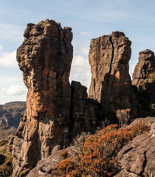
Dramatic Rock Formations
You walk among some of the oldest exposed rock on Earth. Wind, rain, and time have carved the sandstone into unusual rock formations with sharp edges and rounded shapes.
Common features include:
Tower-like pillars
Mushroom-shaped rocks
Deep cracks and narrow valleys
Many surfaces feel rough and uneven. Dark stains from minerals and algae cover the stone, especially near water. Some areas hold shallow basins filled with rainwater, creating small natural pools.
These formations limit where plants can grow and where you can walk safely. They also help explain why the summit looks so different from the forest below.
Meteorological Phenomena
You experience weather that changes quickly and often without warning. Clouds form at the cliff edges and sweep across the summit within minutes. Fog can reduce visibility to just a few meters.
Rain falls on most days, sometimes as light drizzle and sometimes as heavy storms. Strong winds move across open rock, lowering the temperature and drying exposed skin.
Typical conditions include:
High humidity
Cool daytime temperatures
Cold nights with constant wind
These conditions shape erosion and control plant growth. They also add to the isolation that defines life on Mount Roraima.
Conservation and Tourism
Mount Roraima sits within a protected area that balances strict conservation rules with guided tourism. You need to understand legal protection, visitor impact, and species protection before planning a visit.
UNESCO World Heritage Status
Mount Roraima lies inside Canaima National Park, a designated UNESCO World Heritage Site in Venezuela. This status recognizes the park’s geological age, tepui landscapes, and cultural value to Indigenous communities.
UNESCO listing requires the government to limit mining, large-scale development, and deforestation. Park authorities control access points and require licensed guides for most treks.
You benefit from this protection because trails, campsites, and visitor rules aim to reduce long-term damage. However, UNESCO status does not eliminate threats. Illegal mining, unmanaged tourism, and weak enforcement still affect remote sections of the park.
Sustainable Tourism and Challenges
You can only reach Mount Roraima through multi-day guided treks, which helps limit daily visitor numbers. Local guides manage routes, camps, and food supplies to reduce waste and erosion.
Sustainable tourism focuses on:
Small group sizes
Pack-in, pack-out waste rules
Designated campsites
Local guide employment
Despite these controls, tourism pressure continues to grow. Foot traffic damages fragile summit soils, and improper waste disposal threatens water sources. Weather delays also cause crowding at camps.
You play a direct role in sustainability by following park rules, choosing licensed operators, and avoiding off-trail travel.
Protecting Endemic Species
Mount Roraima supports many endemic species found nowhere else on Earth. You will see plants adapted to thin soils, heavy rain, and constant wind.
Key species groups include:
Carnivorous plants such as pitcher plants
Specialized orchids and bromeliads
Amphibians limited to summit wetlands
These species survive in small, isolated habitats. Even minor disturbance can cause long-term harm. Stepping off marked paths or collecting plants disrupts growth and reproduction.
Park rules prohibit removing natural materials. By respecting these limits, you help preserve ecosystems that evolved over millions of years.
Frequently Asked Questions
These questions cover weather timing, trail difficulty, wildlife, geology, cultural meaning, and trip planning. You get clear facts to help you decide when to go, what to expect, and how to prepare..
You get the most stable weather during the dry season from December to May. Trails stay firmer, and clouds clear more often.
You can visit year-round, but the wet season from June to November brings heavy rain. Muddy paths and low visibility can slow your trek.
The trek is challenging and takes six to eight days. You hike through jungle, cross rivers, and climb steep sections.
You need good fitness and steady pacing. Local guides are required, and permits usually come with organized tours.
You find plants and animals that evolved in isolation. Some species live only on the summit.
You may see carnivorous plants, rare orchids, small frogs, and unique insects. Wildlife stays limited due to the harsh summit climate.
Mount Roraima is a tepui, or flat-topped table mountain. Sheer cliffs rise hundreds of meters above the savanna.
The summit holds quartz sandstone, shallow pools, and unusual rock shapes. Waterfalls drop from the edges after heavy rain.
.
Indigenous Pemon people consider the mountain sacred. Their stories describe it as the stump of a giant tree that once held all fruits.
The mountain later drew explorers in the 1800s. Its landscape inspired early “lost world” stories.
You must arrange permits, local guides, and transport in advance. Independent trekking is not allowed.
You should pack rain gear, sturdy boots, and camping supplies. Physical training before the trip helps you manage long hiking days.